1 January 2014 / #rain #snow Just how hot/cold/rainy/snowy was it in 2013 anyways? Here are some charts...How did Ottawa’s weather in 2013 stack up to previous years? These charts are courtesy of @YOW_Weather , a new twitter feed that publishes info about Ottawa weather data.** Rainfall: ** Total rainfall (as measured at the Ottawa Aiport) in 2013 was 580.6mm. That’s down slightly from year before, which is hard to believe with all the rain we had this summer.[ ](http://ottawastart.com/wp-content/uploads/2014/01/rainfall.png)** Snowfall: ** Total snowfall in 2013 was 270cm, up significantly from the past four years, and certainly one of the higher years on record. Nowhere near 2008, or the “Year of the Shovel”. (The peak in the 1970’s happened in 1970-71, where they had nearly 4.5 meters of snow that season.)[ ](http://ottawastart.com/wp-content/uploads/2014/01/snowfall.png)** Temperature: ** The average temperature was +6.1°C. If we reached that today we’d all be out in t-shirts. Average temperatures in Ottawa have increased by 1.8 degrees since 1873.[ ](http://ottawastart.com/wp-content/uploads/2014/01/temperature.png)WeatherSpark.com offers these temperature stats: * The hottest day of 2013 was July 16, at 33°C. * The hottest month of 2013 was July, with an average daily high of 27°C. * On January 30, the mercury hit +12°C, about 18 degrees above the usual average for that day of -6°C. * From January 4-18, we had 15 consecutive days with warmer-than-average high temperature. * January had 65% of warmer-than-average days in 2013, but was still the coldest month overall with average daily low temperature of -14°C. * The coldest day of 2013 was also in the first month, January 23. The low hit -28°C. (Average low for that day is -15°C.) * The longest cold spell was from February 1-11, with consecutive days with cooler-than-average low temperatures. * 70% of days in the month of April had days with lower-than-average temperatures. [ 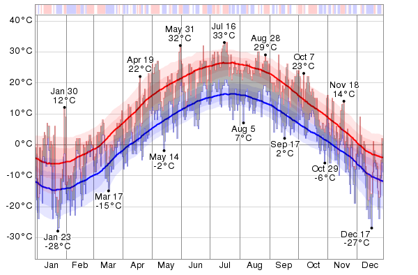 ](http://ottawastart.com/wp-content/uploads/2014/01/temperature_temperature_c.png) The daily low (blue) and high (red) temperature during the last 12 months with the area between them shaded gray and superimposed over the corresponding averages (thick lines), and with percentile bands (inner band from 25th to 75th percentile, outer band from 10th to 90th percentile). The bar at the top of the graph is red where both the daily high and low are above average, blue where they are both below average, and white otherwise. Source: [ WeatherSpark. ](https://weatherspark.com/history/28316/2013/Ottawa-Ontario-Canada)** Wind: ** According to WeatherSpark , the highest sustained wind speed was 21 m/s (75.6 km/h), occurring on October 4; the highest daily mean wind speed was 10 m/s (36 km/h) (November 18); and the highest wind gust speed was 22 m/s (79.2 km/h) (November 1). The windiest month was November, with an average wind speed of 5 m/s (18 km/h). The least windy month was July, with an average wind speed of 3 m/s (10.8 km/h).[ 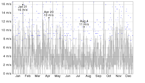 ](http://ottawastart.com/wp-content/uploads/2014/01/wind_speed_windSpeed_mps.png) The daily low and high wind speed (light gray area) and the maximum daily wind gust speed (tiny blue dashes). ** See also: ** Ottawa Weather GuideIf you liked this post, you should ** subscribe to etcetera , ** our free email newsletter. Featuring cool Ottawa events, interesting local news and contests and giveaways. Thanks!